The Oberrothorn – 8.50 miles / Ascent = 746m / Descent = 1,502m
A change in the weather again today as we entered into a more settled spell that would predominate for much of our remaining time in Zermatt. In practice this meant generally clear, bright days, but cooler than at the start of the week with temperatures around the mid-to-late teens of degrees Centigrade – ideal walking weather, really, as long as an assortment of layers were carried.
Given the promise of good, stable weather conditions, we decided today’s objective would be the Oberrothorn, a fairly non-descript lump on the east side of the valley reached by taking all three stages of the Rothornbahn to the Rothorn Paradise at 3,100m and walking from there.
As mentioned, the mud-coloured, pudding-shaped Oberrothorn is nothing special to look at, but it does hold one notable distinction: the 3,415m summit is a superb vantage point encompassing views of no fewer than 38 four-thousand-metre peaks, and is gained by what is claimed to be the highest hiking trail in Europe. I didn’t count each of the summits and I haven’t checked the highest trail claim, but knowing the Swiss penchant for accuracy I’m not rushing to quibble these figures.
Plain it may be from a distance, but the switchback route proved to be an interesting walk with some amazing views on offer. Obviously, as we were undertaking a mountain climb, it was only natural to set off walking downhill from the gondola station – a descent of some 130m before the climbing began. We were heading for a junction of paths at small saddle marked on the map as Furggji, and all the while a helicopter buzzed disconcertingly close overhead, delivering building materials to the gondola station.
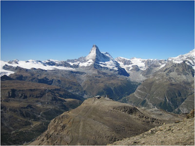
The route from the saddle to the summit of the Oberrothorn is another themed way – the Weg Zur Freiheit (the Freedom Path) – a clear path dotted at intervals with a series of stained-glass “eye” sculptures, each of which was adorned with information on different aspects of the philosophy of nature. Physical nature was also on display, as can be seen in this picture showing the valleys radiating from Zermatt.
From the saddle the route zig-zagged upwards almost without respite. Generally, though, the gradients were not too bad, the path was clear, and loose rock and scree provided few problems. In one or two places – avoidable viewpoints, in the main – there were some long, steep drops worth being wary of where a fall is definitely not recommended, as it would likely end your holiday there and then.
At our usual dawdling pace it took us about 1hr 45min to reach the top – a small, rounded rocky summit with 360° views and a fearsome drop off to one side. Many of the mountains around here are so high and difficult to reach they are outside the compass of most walkers, so it was quite nice to be standing on the actual summit of an actual mountain for the first time all week. It was also (we think) the highest point we have ever reached on foot.
It was pretty cold and windy on top, so we stayed for a few minutes to take in the views then dropped down a little way to find a more sheltered spot for lunch.
Afterwards we retraced our steps as far as the saddle at Furggji, then instead of returning directly to the top gondola station at Rothorn Paradise, we took the lower path towards the middle station at Blauherd – about another 45 minutes walking – before heading down to Zermatt.
We were back in town by mid afternoon. Although we had enjoyed our walk very much, we felt we had not made full enough use of the day. As the weather was good we decided to ride the gondola to Furi, have a drink, and walk back to Zermatt: a few extra miles added to the total, and a gentle warm-down in the late-afternoon sunshine.


Hmmmmm...... Lord of the Rings and the Eye of Sauron. But what fantastic scenery, and how blue is that sky. Wonderful.
ReplyDelete